| Coastal
Regulation Zone Information of Andhra Pradesh |
 |
| | ||
|
Objectives
& Methodology | ||
|
Home | Objectives The main objective of this study is to create Coastal Regulation Zone Information System for Effective Management of the Coastal Zone of Andhra Pradesh. Methodology: The flow chart format is shown below 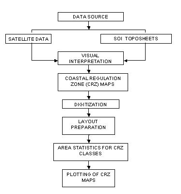
Coastal Regulation Zone map on 1:25,000 scale derived from satellite data were collected from Ministry of Environment and Forests, Government of India. The georeferenced coastal regulation zone maps were digitized in ARC-INFO GIS. Digitised maps were edited, labeled and layouts were prepared. The area statistics of different coastal regulation zone class in the maps were generated. The secondary data have been collected from various departments and organised into GIS. | |
|
Home | Introduction | CRZ | Study Area | Objectives & Methodology | Results | ||