| 
Home
Introduction
CRZ
Study Area
Objectives
&
Methodology
Results
|
Coastal Regulation Zone of Kanchipuram
District
Geographic Location:
Kanchipuram
coast stretches between Tiruvanmiyar and Chunampet. Geographically it is located
between 12° 20'-12° 52'30''N latitude and 79° 20'-80°17'30''E longitude. This
coastal district covers an area of 4963 sq.km.
Physiography:
This
coastal area comprises sandy beach with beach sand.
Geology :
The
geological formations are beach sands of quaternary and recent period, Cuddalore
sandstone of Mio-pliocene age, shals and sandstone of Upper Gondwannas and charnockits
of Archaean era.
Geomorphology:
The
coastal area of Kanchipuram district is characterized by several strand lines,
lagoons, mangroves, salt marsh, estuaries, creeks, barrier dunes, spits, beach
terraces etc
Natural Resources :
The
ground water occur under water table conditions. The major water bearing formation
being the coastal sands extending 30-40 feet. Sand thickness is increasing towards
coast. In many places the coastal water is brackish in nature due to the presence
of Buckingham canal running parallel to the coast. The major zone of ground water
occurrence is the Palar mouth where the Palar river bed acts as a potential formation.
The important mineral found
in this stretch is silica sands along the Mamallapuram coast.
Fig: Coastal
Regulation Zone of Kanchipuram District
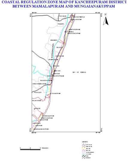
Distribution Coastal Regulation Zone:
The
different coastal regulation zone class of Kanchipuram District coast and their
area extent are presented in the Table.4
.
Table.4: Coastal Regulation Zone classes and their area extent of Kanchipuram
District
| CRZ-I
sq.km | CRZ-II
sq.km | CRZ-III
sq.km | LTL
km | HTL
km | 100m
line km | 200m
line km | 500m
line km | | 8.95 |
5.15 |
16.8 |
78.03 |
139.44 |
Nil |
65.23 |
75.25 |
Human Settlements:
The district
comprise of three divisions (Kanchipuram, Saidapet and Changalpet). and eight
taluks viz, Tambaram, Kanchipuram, Sriperumbudur, Tirukkalukkundram, Cheyar, Madurantakam,
Chengalpattu and Uttiramerur. The total population of this district 24,42,179
out of this 12,44,756 are male and 11,97,423 are female.
Tourism:
Mamallapuram,
Vedanemili, Muttukadu, Golden Beach, MGM, Young Little Folk, Kishkintha, Vedanthangal
and Poondi are the important tourist spots in Kancheepuram coastal area. More
than 1.5 lakh peoples visit these places in a year.
Industries:
This
Coastal area includes major industries such as Madras Atomic Power Plant at Kalpakkam.
This plant generates 640 MLD of effluent. The treated effluent after monitoring
is disposed into sea.
Climate:
Both
the monsoons occur here and in summer heat is considerably mitigated in the coastal
area by sea breeze. During April and May the temperature may go up to 40°C and
during winter the temperature does not fall below 18° C. The annual rainfall is
around 1200mm.The entire coast is affected by gales and cyclones during North
East Monsoon
|