| Coastal
Regulation Zone Information of Tamil Nadu |
 |
| | ||
|
Tirunelveli
District | ||
|
Home |
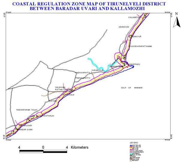
Geology: Distribution of Coastal Regulation Zone: The different coastal regulation zone class of Tirunelveli district coast and their areal extent are presented in the Table.11. Table.11 Coastal Regulation Zone classes and their areal extent of Tirunelveli
Natural Resources: Water Archaean and sedimentary formations are traversed in coastal areas, comprising of sand, clay, sandstone, calcareous sand with shall inclusion, laterite, lateriate ganges, granite gneisses, charnockite, pegmatite and quartz . Dug cum bore wells and shallow tube wells are prominent in this area. The water table has been highly depleted due to extraction of ground water for irrigation. Mineral This coastal belt is rich in garnet illuminate and monazite sands . Human Settlements: This district has seven taluks namely Radhapuram, Nangunery, Palayankottai, Ambasumudram, Tenkasi, Sivagiri and Sengottai. The present population of this district is 2,501,832 in this 8,03,839 are male and 7,96,510 are female. Seventy one percent of people in this district are literates Climate: The factors that influence the climate of this stretch are the two monsoon winds the proximity of sea and the dwindling height of the western ghats. Due to the absence of hill ranges of considerable height, the monsoon do not precipitate heavy showers. The south west monsoon also bring showers in the months of June and July and this season is locally called as Saral. The period from January to May is marked by unusual hot climate with 38ºC. The coldest month is December with a temperature of 25ºC. | |||||||||||||||||
|
Home | Introduction | CRZ | Study Area | Objectives&Methodology | Results | ||||||||||||||||||