Coastal
Regulation Zone of Thiruvallur District:
Geographic Location:
The
coast of Thiruvallur is located between 80º02'30''E - 80º22'30''E Longitude and
13º 15' 00''S - 13º 35' 00''S Latitude.
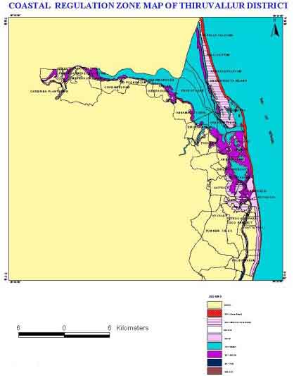
Fig: Coastal
Regulation Zone Information in Tamil Nadu : Thiruvallur District
Physiography of the Coast:
The
coast consists of sandy beach with beach sands and extend over a width of 500m.
from the coastline.
Geology of
the Coast:
The
main geological formations occurring in the coast are upper Gondwana sand and
silts, Quaternary sand and clay undulation by Archean crystalline rocks (Chornockite).
Coastal Geomorphology:
This
coast has a very vast coastal plain, which extends from North of Toppala Palayam
to South of Sattangadu. There are three strand lines, with intervening broad tidal
flats occurring in the coastal plains. Lagoon, Mangrove swamps, Salt marshes,
Estuaries, creeks, sand dunes, spits and beach terraces represent the marine landforms.
The coastline is mainly accreting with noticeable erosional effects particularly
near Ennore. Development of off shore bars and shoals are observed near Ennore
and Pulicat.
Distribution of Coastal Regulation
Zone:
The
different Coastal Regulation Zone class of Thiruvallur district coast and their
area extent are represented in Table.2.
Table.
2: Coastal Regulation Zone classes and their area extent of Thiruvallur
| CRZ-I
sq.km | CRZ-II
sq.km | CRZ-III
sq.km | LTL
km | HTL
km | 100m
line km | 200m
line
km | 500m
line
km |
| 32.87 |
Nil |
13.62 |
96.12 |
160.78 |
Nil |
27.55 |
85.42 |
Natural Resources:
Water:
In
this coastal area, the coastal alluvium and river alluvium are overlying the crystalline
rocks. Wherever the alluvium consists of coarse sand they form good aquifers.
In this region the area between Araniyar and Korataliyar, have potential aquifers
Mineral:
Mineral
resources in this stretch include silica sands, lime shells and salt.
Flora And Fauna:
The
coastal Flora and Fauna is more associated with estuarine system of Ennore creek.
Human
Settlements:
This
district comprises of seven taluks namely Ponnary, Poonamallee, Ambathur, Gummidipundi,
Uttukkottai, Pallipattu and Tiruttani. Seven villages are situated in the 200m
CRZ and 500m CRZ lines. The existing population of Tiruvallur district was 22,11,414
out of this population 11,29,937 are male,10,81,477 are female and 12,71,767 are
literates
Tourism:
Pulicat
is a beautiful place in the east coast lying North of Chennai. There are facilities
for swimming and fishing. It was a site of old Dutch Settlement.
Industries:
The
coastal area in Thiruvallur predominantly contains a number of a small and heavy
industries mixed with residential zones. Tiruvottiyur is exposed to large sea
erosion due to tidal waves during monsoon. In Eravanoor and Kathivakkam a number
of big industries manufacturing fertilizers and automobiles have come up. There
is large number of industries like Petrochemical, Fertilizer and Refinery situated
in and around Manali area.
Climate:
Both
the monsoon occurs here and in summer heat is considerably moderate in the Coastal
Area because of the sea breeze. During April and May the temperature may go upto
40°C and during winter the temperature does not fall below 18°C. The annual rainfall
is around 1200mm.The entire coast is affected by gales and cyclones during North
East Monsoon.