|
|
International
Research Collaborations
|
|
|
The Department of International Development (DFID), United Kingdom, has sanctioned the "Integrated Coastal Management Training" project to IOM in the year 1999. For this purpose, the DFID has allocated £ 810,850 (Rs.550 lakhs) from the bilateral TC funds for a four-year period (1999-2003). The main purpose of this project is to establish the capability to train key Indian personnel in Integrated Coastal Management (ICM) and the capacity to provide relevant advice to GOI on ICM issues. The goal of this programme is to achieve habitat conservation and sustainable use of coastal resources in India during the past two years. Already IOM has trained more than 30 senior level government officers from various maritime states of India. The first phase of the training was conducted at the University of Newcastle, U.K and the second phase of training was conducted at Institute for Ocean Management, Anna University. Erossion and Accretion Zones of the North Chennai Coast: 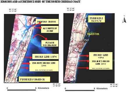
The Ministry of Environment and Forests, Government of India is coordinating this programme. Integrated Coastal Management (ICM) is based on a rapidly evolving set of concepts, principles and decision support tools designed to provide guidance for the planning and management of human activities in coastal areas. The module examines the objectives, concepts and principles of ICM, and the available guidelines and associated tools for use in integrating social economic and environmental factors into the successful implementation of ICM initiatives with emphasis on Indian ICM. Aims:
Participants would have gained an understanding of the principles and concepts of integrated management of coastal areas, and the economic, legal, environmental, physical, biological and sociological framework of coastal area management. By means of a variety of lectures and group discussions, participants will gain insights into the potential areas of conflict between stakeholders and the role that integrated management may play in solving conflicts and promoting sustainable use of coastal resources. top of page 2. Indo-UK Link Project on "Management of Coastal Environment in North Chennai, Tamil Nadu for livelihood security of coastal communities" Lagoons provide nursery and breeding grounds for many species of marine fauna. Pulicat Lake, which is a backwater lagoon, serves as a nursery for fish and prawns and supports commercial fishing with major fish landing centers at Pulicat and Arambakkam. Recently lagoons of this type are experiencing an accelerated decline in water quality & siltation and a possible solution to this has been the focus of an integrated approach for the cause and effects of this degradation. Approximately more than one lakh people depend on the Pulicat Lake ecosystem. This study has focused on the social aspects for the sustainable livelihood security of the fishing communities through the INDO-UK link program by transferring the social policies developed by the UK collaborators through the Indian collaborators. During the first year (April 2001- March 2002), primary data such as socio-economic status, secondary data on demography of Pulicat Lake and activity impact analyses and land use pattern of Pulicat Lake. The second year of the project is currently underway. Research outputs in the first year of the UK-Link Programme have achieved the identification of the key environmental and social problems facing the North Chennai coast. Preliminary base training of appropriate stakeholders and coastal managers has built capacity for accumulating ICM skills enabling local managers to formulate Integrated Coastal Zone Management for this region. Influence of the Ennore Thermal Power Plant: 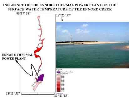 The next stage to the development of improved coastal management is the further development of integrated framework for ICM using both proposed and previous research outputs that considers social, economic, political, cultural and environmental influences on sustainable resource management of the area. This can only be achieved through the formulation and activation of an interdisciplinary team of scientists working alongside local stakeholders and policy makers. The collaboration between the Universities in the UK and India has made much headway in achieving such team dynamics, however further research is needed in order to breakdown barriers between policy makers, academia and stakeholders in order to facilitate understanding of the problems on the Chennai coast. Future research objectives are to:
top of page 3. Volkswagen Research Project on "Methane Cycling in Tropical Mangrove Ecosystems of India" Funding Agency : Volkswagen Foundation, Hannover, Germany Amount : DM. 100,000 (Approx. Rs. 20.00 Lakhs) Duration : April 1998 - June 2001 Background: The research project on "Methane cycling in tropical mangrove ecosystems of India", funded by the Volkswagen Research Foundation, was started in April 1998 for a period of two years. The achievements and advantages of the collaboration between the Max-Planck-Institut für terrestrische Mikrobiology, Marburg, Germany and the Institute for Ocean Management, Anna University is dealt with individually below. India, being a dominant rice growing country in Asia, was believed to emit significant quantities of methane (CH4) to the atmosphere. Based on this, the Indian National IGBP initiated a "Methane Campaign" to quantify the actual emission characteristics from rice paddy in India. Their aim was to quantify the basic fluxes of CH4 to the atmosphere. On the other hand, natural wetlands, which are particularly known for high CH4 emissivity characteristics were less studied and understood. For the first time in India, coastal wetlands were studied for their CH4 emission characteristics. Being salt-dominant wetlands, one would expect low or no emission scenario from these coastal wetlands. The emission of such greenhouse gases almost doubled due to the higher temperature regimes in the tropics, in addition to severe anthropogenic stress. It is important to state that CH4 flux is a difference between the total CH4 produced and that oxidized. The flux measurements in general has a very little predictive power as far as the emission scenario is concerned and this project was designed in such way that process-oriented studies was the primary foci of this research work, as shown diagrammatically below. 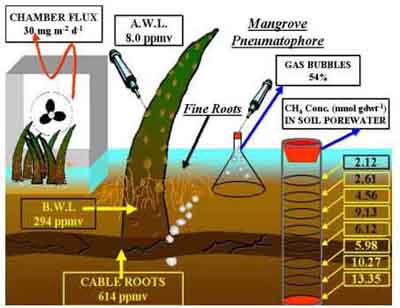 The group at Anna University made extensive seasonal and monthly collection of samples from the mangrove area and analysis of parameters identified for this project was made on a regular basis. These include:
Apart from these routine measurements, specialized analyses were made at the Max-Planck-Institut fur terrestrische Mikrobiologie, Marburg during our exchange visits. Experiment on the effect of trimethyl amine (TMA) on these coastal sediments was successfully performed. These aspects were very critical in understanding the major processes involved in the production and emission of methane to the atmosphere. top of page 4. NERC Research Project on "Nitrification, Denitrification and Nitrous Oxide in Indian Mangrove Ecosystems" Funding Agency : Natural Environmental Research Council, (NERC), U.K. Amount : £ 275,000 (~2.0 Crores) Duration : September 2002 - August 2005 Nitrous oxide (N2O) is an important climatically active trace gas whose tropospheric concentration is currently growing at about 0.3 % yr-1, with implications for future global temperatures and stratospheric ozone. Known global sources are several but their combined magnitude cannot account for the observed tropospheric growth, implying the existence of additional unknown N2O sources. Soils and the oceans are the largest of the currently recognised tropospheric N2O sources and for both; microbially mediated nitrification and denitrification contribute to net N2O production. Current data indicate that tropical soils and coastal seas are particularly important sites in this respect but relevant data are few and for the latter are dominated by studies in temperate latitudes. Regions likely to make a disproportionately large contribution to the coastal N2O source are the mangroves that dominate tropical coasts and are an interface between N-rich tropical soils and coastal seas. Mangroves are very sensitive to global change and anthropogenic disturbance is linked to enhanced N cycling, with the clear implication of increased N2O fluxes. Therefore, accurate projections of tropospheric N2O growth may be problematic in the absence of relevant data from both pristine and anthropogenically impacted mangrove sites. The need to improve our understanding of mangrove N cycling and to evaluate its contribution to the global flux of tropospheric N2O is therefore paramount and should be a high research priority. We will examine the mangrove contribution to global N2O using detailed studies of N fluxes, nitrification and denitrification rates and associated N2O production and atmospheric flux at carefully selected contrasting mangrove sites. Using these data we will develop a generic model of mangrove N cycling and N2O flux that should be of value in aiding future predictions of tropospheric N2O growth. These outputs will allow identification of the climatic consequences of mangrove exploitation, information that will aid strategies for sustainable coastal development. Approach to the Project and Specific Scientific Objectives: We propose to study the N biogeochemistry and to quantify the resultant atmospheric N2O fluxes at selected tropical mangrove sites around the Bay of Bengal, principally along the East Coast of India. Our rationale for selecting this region has several aspects. It is globally significant, accounting for more than 7% of the global mangrove area. A consequence of this is that a diversity of mangrove sites can be readily identified, ranging from pristine to heavily anthropogenically impacted and hence involving a spectrum of DIN inputs, both in terms of quality and quantity. In these respects the region can be considered a microcosm of mangrove environments worldwide. Our overarching hypothesis is that tropical mangroves are globally important sites of N cycling, the implications of which involve both the modification of inorganic N fluxes to coastal waters and the production and atmospheric flux of climatically active N2O. These implications are disproportionate to the geographic extent of mangroves and are likely exacerbated by anthropogenic activities including direct nutrient discharges and changes in land management strategy. By specifically focusing on DIN fluxes, rates of nitrification and denitrification and associated N2O production and atmospheric flux at carefully selected contrasting sites, we hope to develop a generic model of nitrogen cycling in mangroves. In doing so we should begin to more adequately appreciate their contribution to the global N cycle and climate. 
Using such knowledge it should be possible to predict the consequences of continued mangrove exploitation and to incorporate this into strategies for sustainable coastal management. Within this context we identify the following specific scientific objectives:
Relevance
to NERC Mission: National and International needs, achievements and outputs
top of page 6. International Foundation for Science Research Project on "Aquaculture Site Selection in Tamil Nadu Coast through GIS and Remote Sensing" Funding Agency : International Foundation for Science, Sweden Amount : SEK 70,000 Swedish Crowns Duration : April 1993 - March 1995 This study was designed to demonstrate that the date collected from diverse sources such as land use, geomorphology, drainage, water quality, soil physical and chemical factors, meteorology, and socioeconomic data can be compiled and merged in a Geographic Information System (GIS). An integration of all these parameters is interpreted to evaluate opportunities for aquaculture development in terms of the most promising locations. In other words, GIS and remote sensing are applied to demonstrate and quickly identify the locations, which are suitable, marginal or unsuitable for aquaculture development in two sites viz., Vedaranyam and Tuticorin in Tamil Nadu. Based on the integration of ground truth and laboratory analyses of water and sediment properties with various thematic maps and other logistic parameters, an area of 34 km2 and 27 km2 have been found to be highly suitable for brackish water aquaculture in the Vedaranyam and Tuticorin areas respectively. Suggestions for promoting environmentally sound aquaculture in wastelands and protecting the ecologically sensitive areas from aquaculture development is highlighted. top of page |
|
|
Home
Infrastructure |
||
|
Home | IOM | Working Staff |Infrastructure|Projects | Training Programs | Research Activities| Publications | International Colaborations| Contact
|
||